https://wilderness.org/keep-our-wild-public-hands-0
The sound is electrifying. It’s like we’re walking under power lines, hearing an ever present buzz....but we’re not. As we move over the trail, flying objects come out of the tall grasses and sage brush that lines the trail. They have yellow stripes visible on their sides when in flight and they are seemingly everywhere. They’re grasshoppers, by the thousands! We’re on the Crystal Creek trail in the Gros Ventre Wilderness area on a beautiful, but cool, Summer morning in August. To get here we drive about 1.5 hours from our campsite at Shadow Mountain in Moose, WY. By the time we arrive at the end of a rutted and bumpy dirt road, the sun has warmed up the air from 38°F to 44°. Our first order of business at the trailhead is to cross the creek so we take off our hiking boots and put on river walking shoes. We unzip the bottom legs off our hiking pants that turn them into shorts and throw our hiking boots over our shoulder. Then we each take a hiking pole and tell Rocket to go across the creek. The crossing is wide as creek crossings go, and about knee deep and the creek bottom is full of rocks and little sand. But most importantly, the water is frigid! We want to move quickly, but don’t because slipping on the rocks and getting our packs wet right at the start would not be a good way to begin the day. As Terry exits the creek onto the bank, I hear a yelp telling me his feet are pink and frigid. When I hit the other side, I too have feet numb with cold. We dry off our feet with a quick drying hiking towel, put our boots back on, and continue hiking this beautiful trail which winds through woods at times, desert landscapes, and lush riparian areas when near the creek. As it turns out, we cross Crystal Creek six times (3 times each way), with the last crossing being the most difficult. As the day progresses, the water temperature appears warmer, although maybe we just get used to it. Of course the air temp rises to around 60°F which also helps. 
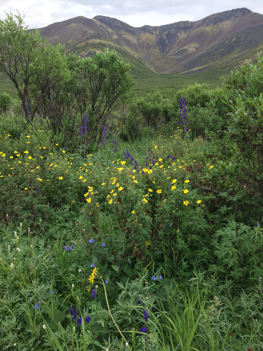
We move through a wooded area that smells of pine trees and fir, and then through the desert area where the distinctive sage brush smell fills the air. As we get about a mile from our destination, the wind shifts, and smoke is the predominant scent. For days now, fires from other states have blanketed the region with a haze and often, the smell of smoke. It gives me a mild headache when we’re in a smoky area for hours, but this is a great hiking trail. We love being in wilderness areas because typically that means no one else is around, and today that’s true - much to our delight. Often it means the trails are overgrown, but this one is well marked and easy to follow. I am hopeful of seeing a bear, a moose or other wildlife. We see tons of grasshoppers and small butterflies, orange and brown ones and yellow ones. We hear the chirping of songbirds in places and hear the knocking of trees as the wind moves through the forest. Also in the woods, I hear the squawking of gray jays and watch them fly through the trees. This trail is a recommendation from the ranger at the Jackson Hole forestry office which we visited in town a couple of days earlier. We are camping nearby in the Teton National Forest and want to find a place to hike with Rocket. He isn’t allowed on the National Park trails in Grand Teton National Park or nearby Yellowstone. I am happy to write that we’ve found a few national parks where dogs are allowed to hike on trails: Wrangell St. Elias in AK, Acadia in ME, Petrified Forest in AZ, Great Sand Dunes in CO, and part of the Pacific Crest Trail running through North Cascades Park. There may be a few more, but most do not allow dogs on trails. In our travels, we always visit visitor centers in the parks and especially like to stop at National Forestry ranger offices. They have information about dispersed camping, hiking trails, maps and wildlife information. The nice ranger we speak with in Jackson Hole tells us that the Crystal Creek Trail is interesting not only because of the diverse environments along the trail, but because at the trail’s end is a natural landslide (happened 10 years ago) on one hill with a deep green pool below. When we arrive there, it’s a bit eerie. The landslide is huge and devastating. The pool is an odd color of green with some gray silt coloring on the sides. There are dead pine trees - long slender gray sticks rising out of the water - and because of the smoky haze hanging over this part of the state, things look even eerier. I do see some Mergansers gliding through the pond. We find an old tree stump to rest on as we have lunch, and then we begin our journey back to the car and the cold creek crossings. I am writing about this hike because it takes place in the wilderness area. We do a lot of hikes in developed areas and often run into other hikers, horsemen, bikers and ATV users. But to us, the best hikes are where there is no crowd, where you stand a chance of seeing wildlife because noise hasn’t scared everything into the brush. And today we don’t see any big mammals - predators or prey. But we challenge ourselves with the creek crossings (maybe that’s why no one else is here), enjoy a long hike with Rocket, and see a very interesting part of the country. Also while in WY, we hike to Grizzly Lake, also in the Gros Ventre Wilderness area. On that trail we run into a cowboy whose two dogs helped move some cows (they’re allowed to graze on public lands), and he tells us there are wolves in the area. It’s exciting as we hike that trail to know they may be in the woods or along the ridge top. We don’t see them, but do see their sign and on two nights at our campsite, we are fortunate enough to hear wolves howling before they go hunting. The Grizzly Lake Trail isn’t as easy to navigate as the Crystal Creek Trail and we go off trail twice - following horse and cow trails. (I blame Rocket who was leading, and is very interested in livestock...he was on high alert when the cowboy came down the hill. Rocket showed no interest at all in the two dogs, but lay down in his herding position and stared at the horse for 15 minutes.). This trail also is more popular and so for our last mile, we see three other couples who begin the hike (one turned around after a half mile). But I think it’s worth writing that while our national parks have great hiking trails, our national forests also have some fabulous hiking opportunities. Our public lands are under threat of being turned over for mining and development, and this is true in Wyoming as well as other states. I hope my blog in its own small way can help people understand how wonderful these recreational lands are and how vital they are to many users. As we travel across America, we are constantly amazed with how many national forests, lakes and streams, and mountains are available for hiking, biking, fishing, ATVing, horseback riding, boating and wildlife viewing. If you are interested in following what’s happening with our public lands and the latest threats, please check out the link below on the Wilderness Society website. And enjoy your public land! https://wilderness.org/keep-our-wild-public-hands-0
0 Comments
Here's a brief look at some stats from the last few months since we got back on the road 6/2/2018 (11 weeks of travel) We have TRAVELED 8,700 miles (RV) We have SPENT $4,598 in gas for both the car and RV We have CAMPED for free 35 nights We have CAMPED in 40 different places in 78 days Our favorite place this trip is Holly: Valdez, AK, Terry: Haines, AK Rocket: Keno City Music Festival, Yukon. The most we've paid for a gallon of gas was $5.06 (in Inuvik, Northwest Territory) - lowest was $2.47 (Danville, VA) We have seen 101 bears: 76 Grizzly, 25 Black Bears We have seen 343 Eagles (bald and golden), 3 coyotes, 500 Ravens, 3 wolves, 4 porcupines, 36 moose, 3 mink, 6 foxes (red and gray), 1 muskrat, plus lots more wildlife. Most unusual sighting - Canada Lynx hunting a snowshoe hare SINCE WE BEGAN MAY, 2015
We have TRAVELED over 60,000 miles We have VISITED 48 National parks and monuments We have STAYED in 54 State Parks We have CAMPED on 12 Bureau of Land Management (BLM) properties We have CAMPED & HIKED in 66 National Forests We have SPENT time in 10 Canadian National Parks in 6 Provinces We have TAKEN over 30,000 photographs Could you live in a really small town, more like a village, of 50 people? A town at the end of a dirt road 40 miles long where during the winter only 14 people live? How about a town of 87 in the Tongass National forest, a rainforest in southeast Alaska that gets up to 40 feet of snow? A place where your mail, which comes in on a mail plane twice a week, weather permitting, can be delayed as much as 28 days? These words describe the last two towns (if you dare call them towns) we visited over the last 2 weeks...first Keno City, Yukon Territories, Canada and then Hyder, Alaska. Keno City was a last minute decision...a destination we chose not because we were going to visit the town’s mining museum (it’s biggest attraction), but to attend the Keno City Music festival. We were looking for our next spot, something south of Dawson City, Yukon as we make our way back to the US. I overheard the visitor center young man telling another traveler about the festival and he printed a flyer from his computer which listed the acts. He said it was an annual event kept free to draw in folks from surrounding towns and that there was free camping too. Terry asked him about the quality of the dirt road, and off we went. To Terry’s dismay, the gravel road while maintained, had many a pothole and was washboarded in a lot of spots. We traveled very slowly but before we even started this gravel road, we took a rock to the RV windshield and had stopped for an hour to plug the hole using our last windshield repair kit. (We bought several of these the last time we traveled the Alaska-Canada Highway). On this trip to AK, the windshield already took another crack on the bottom passenger RV window. We were told by an auto repair guy we met in a visitor center parking lot to carve into the window a small circle around the spot to keep it from spreading....this worked until it got really hot one day and the crack spread, but only about six inches, and it’s not that noticeable where it is. But the new hole hit just above Terry’s eye line on the driver side. Keeping our fingers crossed, this one hasn’t spread over the course of 12 days. (By the way, while on the road to Keno City, our car took a rock and that windshield is now cracked!). When we arrived in Keno City, we discovered the camping at the festival was not suitable for our size rig, but we got the last spot at the town campground - $15 Canadian/night - no hook ups. We went to hear the music after dinner, as acts started at 1pm and went into the wee hours of the night (camping down the road worked out for the best since we could sleep better miles away from the action). As my daddy used to say, “there ain’t no such thing as a free lunch.” Concert goers were encouraged to make a donation, to buy food, or even to purchase local homemade brews for a donation. I tried just one that was made with spruce tips in it and like that flavor, but I had brought my own cooler which was allowed. As you can imagine, a free music festival involves some poor musicians and some very good ones as well. The festival organizers had sponsors to cover expenses, and all donation money would be split between bands or acts. In the end, I think each of the 20 groups received $300, but I will say this, they had fun. In fact they come here from Whitehorse (Yukon’s capital), Manitoba and other regions, and they all appeared to be having a great time, in spite of the rain. Did I mention the rain? It spitted and rained off and on Friday, but Saturday it rained in earnest all day and into the night. I think it stopped around 10pm Saturday for a few hours, but by then everything was drenched. The dance floor had long since become a mud pit, and even when the locals took some cut trees, having slashed the branches off, and tied them to the bleachers and lashed tarps over top, folks couldn’t help but get wet walking around the venue. We danced in the rain, enjoyed some of the acts and tolerated the half hour sets of the really bad performers, and were comfortable in our chairs that are portable and rock - with umbrellas over our heads. But Rocket had the time of his life. In addition to the two-legged concert goers, there were at least 17 dogs (and many more in the camping sea) at one time near the bleachers and bonfire. Rocket spend his entire time in herding position, ever watchful of the melee. During the bad acts, we watched the dog action with great pleasure. Someone would invariably toss a stick for an eager fetch fanatic, and the chase would begin. Rocket moved ever closer to the fetcher, but always in herding position - never taking the bait himself. Dogs ran after the sticks and eagerly returned to drop them at the thrower’s feet or some other unsuspecting patron. This went on until an organizer asked folks to stop throwing sticks (afraid of a dog fight, I guess) and then would resume within an hour when a dog would retrieve a stick and drop it at the feet of another patron. The dogs were mindless of the rain and each night Rocket came home soaked, but he performed his duty diligently all night at the concert grounds, herding the dogs and posing for photos. There was also an impromptu game of tag the nights children were there (Friday) which unsuspecting patrons were quickly drawn into...I got tagged and spent some time running around the bonfire trying to catch young agile players. Some of the acts we enjoyed included Pablo and Sasha, Kenzie Jane and Dana Lee, and Black Street Jarvis. On Saturday night we spent a long time waiting for one group to set up (all the others took mere minutes, but this one required over half an hour) - Tonight the Moon. When they finally began their set, it started with computerized chords, long sustained electronic moans. After giving it about 10 minutes and hearing no melody, we packed it in and left, as well as many others. To us, it was just noise. Keno City’s 50 residents are never all there at once, and only 14 over winter. In fact, most only come for a stay in the summer to their “camp.” I believe they all have staked a claim, and many will work it during summer. They told me even I could stake a claim for $10. I’m not sure how many of them have found much gold on their claims, but it is a beautiful place to spend your time, as long as you bring all the provisions you need. There are two bars, the museum, some cabins and rooms for rent, and a snack shack...but no grocery store nor gas station. There is hiking around and skiing in Winter, ATVing and gold panning. An active silver mine is being worked and lots of the time, geologists are the only visitors to town. We got our “passport” stamped (see last blog) and left Sunday morning for a muddy ride back down the road, named the Silver Trail. The clouds parted along the way, revealing nice small lakes and green mountain tops, but I don’t think I could make my home at the end of this dirt road with so few residents. We headed for another town at the end of a road...another town with a rich history of mining, a once booming gold rush town of 264 people in 1929, reduced to a few dozen now. But this town, Hyder, AK, drew us not for the music, but for the bears who come in each year July-September to feast on spawning salmon. This small town we’ve been to before, back in 2016. It’s in southeast Alaska in a rainforest on the coast, just over the British Columbia border. Interestingly enough when you enter from BC, there is no Customs station, just one when you leave and re-enter Canada into the town of Stewart. Stewart is where you’ll find gas, propane, hotels, grocers, and shops, no bank though. They hosted their yearly Bear Festival this past weekend (which we attended). But if you stay in Hyder and go to the bear viewing boardwalk maintained by the US forestry service ($5.00/day or $10/3-day pass), you have limited services. Hyder has no grocery store, just a shop selling cheese and one selling fudge and a third store under renovations. I don’t think locals mind going through customs to shop, but mostly they mail order their groceries (a store in Ketchikan) and get them shipped on the mail plane. So twice a week when the weather is good, mail flies in. But a local told me they ship out their Christmas presents to family in October and receive their own presents in January sometimes because weather can delay the mail plane, and once it was delayed 28 days! Another yearly visitor told me one time the road flooded when he was here visiting to bear watch. He said the evacuees had to put their RVs on a barge and then the people were flown out; those with pets had to stay. He chose to stay for the additional 10 days until a temporary military style bridge was put in place. So it’s a remote town on the edge of the Tongass National forest which is a 17 million acre rain forest. A road from Hyder goes up to Salmon Glacier another 17 miles which is a beautiful spot, but beyond the viewing point of the Glacier lies a rugged road traveled only by a mining company actively working a site. Our sole reason for coming to this out of the way small town was to view bears eating salmon. At Fish Creek the forest service monitors the return of Chum and Pink Salmon coming in to spawn. This year, the fish were late and the creek water level very low when we arrived. For a rain forest, it was dry, having not rained in three weeks. A few brown bears had been in the previous weeks, eating the grass alongside the creek, but no fish. We stayed six days and left on the seventh. On day three, torrents of rain fell and the creek rose at least a foot when we visited in the pouring rain that night. No one was there and they closed early that night (usual hours are 6am-10pm daily July-Sept). The road into Fish Creek had to close, and the town lost power when a tree fell on the lines. We were not concerned because we were staying in a free campsite in the “gravel pit” about .75 of a mile from the boardwalk so we could bike to the bear viewing each day. Most tourists were camping at an RV Park in town (4.5 miles) for $36-40/night and driving to and from the boardwalk. We liked our site which was in an area big enough for about 10 campers because we could easily bike back to the RV for meals. Also, a black bear liked to wander through this gravel pit ringed with Thimble berry bushes and have a snack. We saw him/her on four occasions, and he never caused a problem. After the rain, the salmon started to pour in, tripling their numbers. We had high hopes this would increase the number of bears fishing at the creek. The next night, as I predicted at 8 o’clock, a big beautiful brown bear fished the creek for about half an hour from one end of the boardwalk to the other, allowing all of the attendees to get pictures. Sadly many of our experienced photographer friends who had been on the platform since 6am had left since the light was getting flat and they wanted dinner. (No food is allowed on the platform.) But in our 7 days, we only saw this one brown bear fish at the creek. We did see a shy black bear come and go quickly several times, and we saw six other black bears in Hyder, but not fishing on the creek. It might be worth saying that we did log our 100th bear sighting in 2 months, in Hyder! (Now seen 26 black bears & 75 Grizzlies) In past years, wolves had been known to come fish at the far end of the boardwalk. But it’s been years since they were seen. This year we were fortunate enough to see a wolf come near the boardwalk twice - what a thrill! I got video and a few photos. I think this is a female wolf because she marked her territory after eating, by squatting and peeing not lifting her leg. (I’m not sure if males lift their legs like dogs or not and perhaps both male and female young wolves squat like dogs....someone can google and write me the answer). When you’re serious about animal watching and visit here, you spend many an hour waiting and hoping something will happen. We passed the time watching the salmon behavior, watching otters and minks fish and play...watching eagles and gulls. And we also spent many an hour talking to our fellow bear watchers. We made lots of new friends, some who come here every year with long lenses and expensive cameras - Bob and Sue, Sandra and Rudy...and some who’ve been several times like Dave and Rose, the family of Lisa, Joe and Robbie and Nicole and Cameron. When my camera broke Saturday I had lots of help trying to identify the problem. We didn’t solve it entirely, but I could take video only for two days until I got a cell signal as we were leaving Stewart and contacted Canon. I can now take both photos and video, but I need to get to a big city and buy new camera cards and a new battery. The day we left (Monday), we went to the boardwalk for a few hours. When I arrived at 6:50am (Terry was behind me about a half hour), the wolf was in the creek and I was thrilled to watch her and video tape her (see my youtube channel: https://www.youtube.com/channel/UCbL_454302a9lIw-Z-uDleA She fished and caught a pink salmon. Apparently (according to a film shown at the bear festival), wolves will only eat the brain of the pink salmon which is full of protein. It’s a good thing too as the fish has a parasite dangerous to canids. She took the pink into the tall grass where we couldn’t see what she ate, but she was quick about it. She also picked up dead or dying Chum which can weigh as much as 30 pounds here and she ate two of those. At one point, she moused! She tilted her head with her ears focusing on something in the grass and then lept into the air and pounced briefly. She missed the small critter and went back to fishing. On the boardwalk rules are to keep quiet and there’s no running and no flash photography. A tourist who didn’t understand English or didn’t know how to turn off the flash took several photos even though some of us were whispering “no flash!” and the wolf stared up at the boardwalk and then began to trot down the creek. Before stopping to inspect a fish, she went into the bushes and left the area. We got to watch her for twenty minutes...Terry missed it all. We stayed a couple of hours and then left Hyder. I hope the bear activity picks up because the salmon are arriving in droves. No one knows why there hasn’t been more bears near the boardwalk. There is evidence they are fishing just north and south of here. And we understand that definitely the best time to come is in September. Nonetheless, we had a great time watching the otter mom and her pups, the mink, the wolf and the bears we saw. And meeting so many new bear enthusiasts was also a treat. One day while riding our bikes to town, we watched a black bear swim across a raging river - he swam hard in the beginning and then the river swept him a couple hundred yards down the river before he swam to the bank - I got good video. We also watched eight eagles soar over the mountain tops in town. It’s a special little village at the end of the road (nearly at the end, since the mining road extends just to the mine in the Tongass National Forest). A place where few can eek out a living, where isolation and harsh winters arrive yearly. I think it takes a certain type of person to live in a town as small as Hyder or Keno City. But I’m glad they do, and I’m glad we traveled to meet them. If you know of another tiny town at the end of the road, let us know...maybe we’ll make our way there, especially if bears or music are involved!
The wind was whipping, the sea angry, and fog enveloped the point. But we took off our heavy coats, turned on the camera and watched as we took turns jumping into the swirling tide - the air around us a mere 48° F. No one in the tiny town of Tuktoyatuk (or “Tuk” as it’s fondly known) knew the water temperature in the Arctic Ocean, but one website indicated it was 39° F on 7/31/2018. My husband Terry and I don’t think it was that cold, yet we lasted just seconds in the frigid water. But we had driven 575 miles on a dirt road for days to reach this moment, and we weren’t about to let it pass without dipping into the world’s most northern ocean. Perhaps it’s a bit crazy, and how did we come to be here? It started two years ago when we struck up a conversation at the famed sign which greets travelers on the Dempster Highway in the Yukon Territory of Canada. The Dempster highway is legendary around Dawson City, the town that thrived during the Klondike Gold Rush, a town that thrives today on that rich cultural history and lure of adventure. Dawson City is about 15 miles from the Dempster, and a jumping off point for points north in the Yukon and Northwest Territories. We were here in 2016 after leaving Alaska and drove a few hours up he Dempster for a day trip to Tombstone Park. But the young motorcyclist we met at the sign had come from Seattle, WA and drove his motorcycle up the road, then flown to the town of “Tuk” and dipped his toes in the Arctic Ocean. He said in the future folks would be able to drive to “Tuk” when the government extended the Dempster, and we thought that would be a cool thing to do, drive and dip our toes in the Arctic. We weren’t about to take our RV up the Dempster as the road is rough and long; travelers are warned to take spare tires, and there are few services to help with auto repairs. It’s just not suitable for RV’s the size of ours. In 2016, we were happy for a day trip to Tombstone in our Subaru, but we never forgot what the young man said...one day the road would be open all the way to the Arctic. Ever present in our mind is the saying, “it’s not the destination, but the journey.” But of our latest quest, I have to say it was very much about both. It’s like climbing a great mountain, you know it can be dangerous and exciting and mostly you focus on the journey, but goal is to reach the summit...anything less is not only a disappointment, but an unfulfilled goal. The whole point of taking the Dempster Highway to the end of the road was to reach the end of the road. And how many people reach the end of the road and swim in the waters at the top of the world? Of course you can travel to the Arctic through Alaska via the Dalton highway to Deadhorse, where you then board a bus the last 10 miles to Prudhoe Bay or you can fly to another country. But last Spring when we decided to come back to Alaska, we discovered the road to “Tuk” opened this past November. Here was our chance to join the earliest travelers to the end of the road...a 21st century chance at being a pioneer for a week. OK, that’s pushing it - we’re not like the gold seekers who took months mushing through the snow with hundreds of pounds of supplies on sleds to reach a place that might sap their soul or make their fortunes, but we did meet some adverse conditions. Dempster adventure seekers are met with these words from a travel booklet about the highway (obtained at the visitor center (VCj in Dawson): “Constructing road in the north is complicated. The thick blanket of rock and gravel that makes up the roadbed is designed to prevent the underlying ice-rich permafrost from warming, thus keeping it in its more stable, frozen state. Much of the highway was built in winter, with the gravel being dumped on top of moss-covered permafrost. Only trees were cut; shrubs and other plants were buried by the deep gravel. The roadbed conducts heat more than the surrounding vegetation, and it must, therefore, be extra thick to insulate the frozen ground beneath. As climate warms, keeping permafrost under roads is a challenge. Intensive maintenance efforts are becoming more necessary to keep road on permafrost in a reasonable state of repair.” Here’s a vitally important note: “Good gravel is hard to find here where glacial ice and rushing water have not crushed and rounded the rocks. Abrupt changes in the color of the road surface indicate different local source of gravel, while further on sharp rocks punctuate the road surface, and possibly your tires.”
In both the Yukon and Northwest Territories of Canada, the tourism board has a fun competition for tourists to win an ounce of gold and other prizes. They give you a passport to get stamped at various visitor centers, cultural centers, and historic locations. Before the end of September, you take your stamped passport to a visitor center where they check your stamps, and you fill out an entry form. (You can keep the passport as a souvenir.) We still need a few more stamps in the Yukon (you need at least 10 but can get as many as 37), but I turned in the Northwest Territory one yesterday. (There is a very informative NW Territory VC in Dawson City where you can turn in passports and get info about the Dempster Hwy and villages along the way.) On the entry form I filled out, they ask a) if you got a flat tire, b) how many flat tires and c) at which km. If you’re a mechanic and looking to start a business in Canada, I might suggest contacting the tourism board to find out which kilometer along the Dempster most folks have a flat! We saw plenty of people who had flat tires..one guy got one just at the point by the ocean, and there’s no tire service in “Tuk” (luckily he had a spare). But back to the journey....so imagine traveling from northern Vermont to the suburbs of Washington, DC on a dirt and gravel road. That’s the equivalent of our trip, one way. We took 6 days for the journey up and back, stopping for two nights to hike in Tombstone Park. Here’s a bit about our accommodations. We left the RV in the parking lot of the Dawson City Visitor Center which has 24-hour surveillance and was free! (I wonder as traffic to “Tuk” picks up if the VC will be able to offer this service or if short term RV storage is another business opportunity for someone in Dawson.) We brought a three person tent, sleeping bags, and mattresses, plus camp stove etc. that we had purchased for hiking the AT. We filled the Subaru with this gear and Rocket and headed off with 8-9 days supply of food and 5 gallons of fresh water. Tombstone is only about three hours from Dawson City and has spectacular scenery with green mountains through which clear streams run. Home to grizzly bears, Dall’s sheep, two kinds of caribou, wolves, Peregrine falcons and other wildlife, we were eager to hike there and hiked four trails. We stayed at the only campground in the park which has pit toilets, picnic tables, and fire rings. There’s water but it has to be boiled, and there’s no electricity. We loved the campground, and we had a spot (#13) right on the creek which supplied wonderful white noise to fall asleep to, drowning out any nearby camper noise. The tent was quite roomy even with Rocket inside. Terry and I had bought lightweight, easy to inflate mattresses for our AT hike, but Terry’s has a leak which was a problem. He couldn’t find the leak to patch so had to supplement his padding under the sleeping bag with towels and blow up his mattress periodically through the night. (Needless to say, he’s happy to be back on our foam mattress in the RV now - me too.) We had afternoons in the mid 60’s and at night were snug in our sleeping bags while it was in the 40’s outside. Tombstone is still in the Yukon, and we love the Yukon territorial campgrounds which nearly all have really large and private campsites with free firewood and no electricity, but cost only $12/night Canadian (about $9 US). We hiked a fairly flat trail one day by a stream, and one up into the mountains another day, plus added short trails to a beaver pond and hiked the Hart River winter road where the caribou winter. The large Porcupine Caribou herd which numbers between 130,000-197,000 is only here in the Winter so we didn’t see them. The Hart River herd is comprised of about 2,200 woodland caribou but have dispersed for the Summer and can be found in small family groups. We didn’t see any of them, but the lichen and mosses they thrive on cover the hillsides and bushes and are evidence of why caribou enjoy this area. We saw beavers at work, an older cow moose alone feeding in a pond, falcons and hawks hunting, but no bears or wolves. We were eager to finish our quest to reach the Arctic so we left after two nights. Our next overnight was in Nitainlaii Territorial Park in the Northwest Territory. The name is a Gwich’in term meaning “water flowing in out in all directions.” To reach this part of the highway, you have to take a short ferry across the Peel River. The extensive wetland here supports considerable bird life and supplies water to the nearby village at Fort McPherson where I was able to try the dried whitefish the locals are fond of...me, not so much. This campground was not much scenically, and there was no creek to lull us to sleep; however, what it lacked in atmosphere, it made up for with hot showers! The water is heated by a generator which only runs a few hours in the morning (9-11am) and from 4-9pm so we were in luck after spending three days traveling and hiking; it was a welcome pleasure and well worth the $24 Canadian price/night. Ten kilometers from the campground, you board another ferry to cross the confluence of the Arctic Red River and the Mackenzie River. This is a wider water crossing than the Peel, requiring a bigger boat which makes two stops. It goes from one side of the Dempster to the other, but also travels to the village of Tsiigehtchic (“mouth of the Iron River”). We went into this tiny village on our return trip to get our passport stamped and arrived when the staff at the small VC was at lunch. We didn’t want to wait an hour and there’s not too many attractions to tour (a cemetery and a short lake trail), so we waited by the water and got back on the ferry (this took 1.5 hours) where they stamped our passport on the boat! Here is the Mackenzie Delta which is beautiful with winding rivers and wetlands and flat land with lush green vegetation. As we move closer to the Arctic, the landscape is not at all what I expected. I pictured it would be barren, colorless, and flat. We passed through the Richardson Mountains and Ogilvie Mountains the first 535 km of the highway and will spend over 100 km in this delta which hosts Canada’s longest river (Mackenzie) running 4,200 km from northern British Columbia to the Beaufort Sea. The highway stretches between Black Spruce and Tamarack alongside lakes and ponds to Inuvik, a town of about 3,400 hardy souls, which used to be the end of the road at km 736 (mile 457). (I say hardy because average annual temp is 14°F with coldest temp being -70°F!!) The booklet about the Dempster Highway is highly informative and keeps the long journey interesting by noting points of interest and corresponding kilometer markers. For example, on the cliffs above the road at Km 158 is a Gyrfalcon nest used for years as evidenced by the white bird guano marking the cliff face. Other noteworthy km stops indicate viewpoints or info about the color change in the Red River (heavy iron in the water), the mineral lick where the sheep gather, and other geological features or key wildlife areas. This year, the book stops at Inuvik with no descriptions of the last 174km (90 miles) to “Tuk.” We can tell you that there are no rest stops nor villages, no gas nor tire services. (I suggest they put in a toilet for the 2.5+ hour trip), but there are Pingoes. These are cone shaped mounds with a core of solid ice, unique features in the north. Imagine what happens when freezing water in a bottle expands, forcing its way upward as it turns to ice. This is how pingoes form, and some are as big as a car, others as big as a large stadium! To reach them you can hire an outfitter in “Tuk”or take your canoe when the water isn’t whipped up by winds. They are considered Canadian landmarks. When you move out of the Mackenzie delta, you travel through the Klondike plateau where long periods of weathering have resulted in extensive upland boulder fields, v-shaped valleys and low shrubs. I expected this spongy tundra, but it’s more colorful with waterways meandering through than I expected. Apparently in the fall, it’s a beautiful gold and purple as berry bushes change colors. It’s not a land of ice and snow now, and summer brings lots of birds and animals like foxes and grizzlies - both of which we saw traveling just off the road. They seemed surprised by vehicles, and I wondered how their lives will change with the new traffic headed here. People have traveled the 90 miles from Inuvik during Winter on an ice road, but now this maintained gravel road will open up more commerce. It was extremely nice to see how few cars and campers were on the road. When we left “Tuk,” we drove two hours without seeing anyone, except a grizzly running away from the road. When we did see folks on the Dempster, they waved as though we were all part of a shared grand adventure. A note from the Dempster booklet describes the northern boundary of Tombstone. “Watch for Arctic Terns skimming or hovering over the water. The terns nest on gravel bars in the braided channels of the river. They are among the long-distance champions of the bird world. From here, they will migrate nearly 20,000 kilometers to have another summer in Antarctic regions. These birds experience more hours of daylight every year than any other species on earth!” Which brings me to the sun... We arrived in July, when the folks in Tuktoyaktuk have nearly 23 hours of daylight. It rose at 4:28am on July 31 - the day we arrived and set at 1:32am the next day! When I got up in the middle of the night to walk to the port-a-potty around 3 am, it was very light. In he last 5 weeks while we’ve been in the north (Yukon, AK, etc), we haven’t needed flash lights nor solar lanterns. It’s even been difficult for me to get to sleep because it’s so bright! Terry pays attention to the sun’s track so when we’re in the RV, we can position our portable solar panel to capture the sun while hiking. This far north, the sun doesn’t just move from side to side, it arcs in a circle which is quite interesting to calculate. But here’s a bit more about our accommodations in “Tuk”. The road ends at the “point.” Here the surf was crashing on large rocks, with no visible beach for part of the point. But about 75 yards around the very small point, was an area you could walk into the surf where it wasn’t crashing onto rocks. This is where we took our dip. Along the edges of the point are a smattering of picnic tables, a few fire rings and places to park a truck camper or pitch a tent. There were eight of us that night, but the visitor center staff told us as many as 30 RVs were here over the weekend. When we arrived around 6pm, the winds off the water were whipping our tent in a frenzy. Together we managed to put it up, and Terry staked it down securely as we worked with the car as a buffer between the ocean and tent. We had driven all day on the washboarded, potholed, dusty at times, muddy at times road and lost an hour moving into mountain time. We decided to eat out rather than try to light our tiny backpacking propane stove and cook a freeze dried meal in the cold wind. BUT, we had stopped at the tiny (small shed size) VC and learned that with the approaching storm, tomorrow’s weather would likely mean colder water temperature. Reluctantly, I agreed with Terry we should take our dip tonight in the misty rain and cold air (48°F) rather than wait and hope for sunlight. So before heading out for dinner, we put on our bathing suits, then warm coats and grabbed a towel. When I look at the videos of both our dips, I’m surprised how quickly we were in and out! In fact the water temperature, reportedly 39°F according to the Internet, was not that cold - more like upper 40’s, we think. So after changing clothes, we headed into town to the one restaurant - End of the Road! (There is also a carry out place, Grandmas Place.) We were quite surprised at the wonderful mushroom and green pepper pizza ($37 Canadian). They don’t serve beer, but I brought in one in a water bottle. We predict this place will see quite an increase in revenue now that the Dempster Highway extends here. In fact, we think this little sleepy whaling town of 962 Eskimos (Inuvialuit) will change quite a bit in the coming years. Right now there’s not a lot to do in town, and there’s no pay campground which I’m sure will change. The store hours are posted on the latrine at the point, only open a few hours on odd days. You are encouraged to talk to the locals (mostly Inuvialuit or Gwich’in) about their culture, and they’re very welcoming. Had we stayed longer, I would have found it fascinating to hear about life here where they subsistence hunt Beluga whales, muskrat, caribou and moose and live on the coastal barrens. There’s not much in the way of souvenirs; although, there is a bumper sticker that boasts, “I made it to Tuk” ($5). We saw one advertised in the tiny VC, but I’m not sure where you can buy them...probably at the convenience store side of the restaurant. I didn’t think about it when we were there for pizza, and we left at 6:30am the next morning, so we didn’t get one. If someone reading this decides to make the trek, I’ll give you $5 to get me a sticker! They don’t sell them in Dawson City; you just have to go to the end of the continent to purchase memorabilia of your trip to this northern frontier. As we were leaving Tuktoyaktuk, we saw a muskrat swimming in the pond near the point, with his mouth full of grass. Muskrat are an important source of fur for Inuvialuit, and every April there’s a Muskrat Jamboree in Inuvik. We hadn’t seen any muskrats in the last 3.5 years, so that was a nice bonus. All told on the six-day trip accumulating over 1200 miles we saw the following wildlife: 17 Ptarmigan, 1 muskrat, 1 grizzly, 42 loons (yellow bellied), 3 Gyr falcons, 1 Lemming, 41 eagles (bald and golden), 390 Ducks, 1 Red Fox, 1 Hawk, 6 moose, 25 Sandhill Cranes, 2 beaver, 72 Tundra swans, 1 Hoary marmot, 18 squirrels, 1 Peregrine falcon, 6 snowshoe hares, and 87 ravens. We traveled through mountains, taiga, delta and tundra and loved nearly every minute (minus the time mosquitoes plagued us in a few spots)! |
AuthorFormer documentary film producer, wife and mother of one...I'm taking time off to see the US with my husband Terry. Here's where I'll write about our adventures RVing until the money runs out! Archives
August 2021
|