Within a couple hours of our arrival in Waterton Lakes National Park in Alberta, Canada we had seen 4 bears! Actually, Terry saw 4, and I saw only 1. We felt fortunate to get a campsite on a Thursday morning because they sell out quickly, but the RV needed propane. So after securing the site, Terry drove into town to get the RV filled while Rocket and I walked to a nearby lake. We were in bear country and signs to the lake and at the campground posted notice that a bumper berry crop was bringing bears into these areas. I had left my bear spray in the RV, but Rocket and I were on alert. We noticed Thimbleberries along the trail were beginning to ripen and along the road to the trail, Saskatoon berries were plentiful. We saw people, squirrels, deer and dogs….but no bears. Terry on the other hand, saw a black bear with a radio collar along the campground road within minutes of parting from us! Then a few miles down the road heading to town, he saw two bears foraging near the golf course! He knew I was going to be sorry I did not go on the propane run, but little did we know there would be more sightings over the next 6 days. Once we returned from our walk and Terry with the RV, we went back near the golf course and saw a black bear, making it 4 sightings for the afternoon, in a very quick couple of hours. 
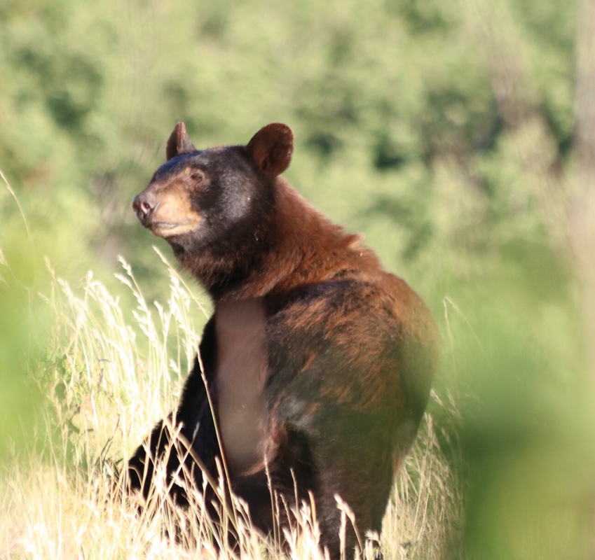
Waterton is an International Peace park, established as the first such park in 1932. It was created and stands today as a symbol of peace and goodwill between Canada and the US. Bordering Montana, the park is the “other side” of Glacier National Park, one of our favorites and we decided since the border was only about 50 miles away, we would check it out. We loved the wildlife sightings, the wonderful hiking, and Crandell Campground. Waterton is a small park by Glacier’s measure…a mere 124,000 acres compared to over a million. But the wildlife viewing, scenery and hiking is outstanding! There are 3 campgrounds, Townsite is right in town and appropriate for those who like the convenience of shopping, restaurants, electricity and water hookups. Belly River is a secluded area but not close to the main arteries for hiking, biking and boating. Crandell, where we stayed, lies in a montane forest and is for those who like their campsite “more sheltered and removed from town.” It lies along one of the main corridors, the Red Rock Parkway, which cuts through the beautiful Blakiston Valley, a place to watch for wolves, bears, coyotes, deer and other wild animals. Another important corridor is the Akamina Parkway, a 16km road that dead ends at the beautiful Cameron Lake set against Carthew Summit, a 20km trek up. At the lake you can rent canoes, paddle boats or kayaks, have ice cream or picnic, even take a dip. It's a beautiful setting and along the Parkway are some great hiking trails. One day we started a hike to the Akamina Pass, but instead we ended up on a horse trail that no one else was hiking. Offshoots in the first few km lead to two lakes: Forum and Wall. Since it was a weekend day and very hot, we encountered quite a few people in those few km. But for hours, we rejoiced in the solitude of our hike and the wildlife: deer, grouse, and a black bear! We had just finished lunch and turned around for our return hike when we heard branches breaking to our left in the woods. Rocket was with us and we all stopped to scout the area when we saw the bear coming out of the woods. I quietly asked Terry to take the camera from my backpack pocket while I held Rocket who was silent but alert. As we watched and Terry snapped some photos, the bear ambled around the brush, crossed the trail about 25 feet from us, and headed off slowly to our right into thick brush. He didn't care about our presence and we respected his movements, leaving him after about 10 minutes. We were thrilled, even though we never found the challenging Akamina Ridge trail described as a “rugged route that climbs up several rock bluffs. It should only be undertaken by experienced hikers who are prepared for mountain conditions.” Before finishing the hike, we took a quick side trail to Wall Lake and jumped in to cool off. Boy did we cool off, in just 30 seconds the water was so cold my toes tingled! We didn't see bears on our other hikes, but we continued to see them from the car as we headed down the Red Rock Parkway to hikes or as we pulled off at the turn-out spot where we could park and scope across the river and onto the golf course - I believe it was the 13th hole - a popular spot for both Grizzlies and Black bears. One day we were returning from a hike by boat and watched a small black bear amble through the picnic area of the town's park! Tourists were snapping photos and eventually, he scurried up a tree. We enjoyed some really long hikes in Waterton. One to Crypt Lake was voted to be one of the world's most thrilling trails by National Geographic. It's a 10-12 mile trek (depending on whether you take the offshoot to Hell Roaring Falls) that starts with a boat ride across Upper Waterton Lake. The hike is 2214’ in elevation gain that includes hiking on narrow ledges (with ropes nailed into the rock side) and offers stunning views of the Canadian Rockies, tumbling waterfalls and clear blue lakes. At one point near the top, you ascend a steel ladder placed into the rock face before you crawl through a natural rock tunnel - not for the claustrophobic. When the trail is crowded (100-300 people/day) it can be a nerve-racking wait on the ledges and rope sides as climbers pass by - there is no stop light! We left Rocket at the RV because of the steel ladder and went on a Monday; there were several morning boats which helped stagger the 150 climbers. The trek generally takes 6-7 hours, and before our boat returned to take us home, we had hiked to Crypt Lake, taken a dip, hiked around the lake to see mountain goats, descended to the offshoot trail to see the waterfalls, gotten to the bottom and jumped off the boat dock into the refreshingly 54° lake, cleansing the dust and sweat of the day off, with time to spare. We met a delightful young woman, Mary Beth Borgstadt, hiking solo on her birthday that day. We enjoyed helping her celebrate, and we all thought the hike worthy of the price (25 Canadian $/person), but Terry and I agree we have been on some hikes that match up to the hype of this Top 20 rating. We took other hikes in Waterton. The Wishbone hike was quite an experience. We took it in hopes of seeing moose, but we didn't. We did however see a coyote, deer and small mammals. The hike was on a multi use trail and we saw some bikers and one other couple in the early part of the trail, but when it branched off to Vimy Peak and we went right, we saw no one else and things got a little dense. The last 4km of this trail are rarely hiked as evidenced by the overgrown vegetation that was waist-high in some places and even shoulder-height in others. I questioned our choice, but we persevered and were rewarded with a view of Middle Waterton lake and a nice spot on a boat dock for our lunch while Rocket played in the water. Best of all, we didn't have to share our spot with anyone else! Another hike was a 26km (16 mile) loop at the end of Red Rock Canyon. The trail takes you along a creekside with views of an open valley, on a steady uphill to alpine lakes with fabulous views of white blooming beargrass, and ends with an easy walk on a wide fire road. We met some park workers heading up past the lakes with gear to take pine cones and seeds from healthy trees in the area. Whitebark pines here are over a thousand years old, but they are on the brink of disappearing in the peace park and across the continent. A keystone species, these trees stabilize the soil on the steep slopes at 2000-3000 meter elevations, decreasing soil erosion and creating micro climates for many organisms. The tree cones produce nutrient-rich seeds that are an important food source for the park's bears, squirrels and Clark’s Nutcracker. One day, terry spotted a black bear high in a tree grabbing for cones. (He was about .75 mile away so no photo but we have some great binoculars!). A foreign fungus, the white pine blister rust and pine beetles have devastated the pine trees. But working with Glacier’s Native Plant nursery, staff and volunteers have been planting thousands of seedlings, hoping to tip the balance in favor of this important species. It's nice to see the collaboration of both countries in this restoration effort. There's lots to do here…we went to dance demonstrations by members of the Blackfoot tribe. Their members range from Montana to Alberta and they were fortunate to have maintained their ancestral lands, unlike many Native Americans who were forced to resettle elsewhere. We also attended a ranger talk on wolves and ate out at Pizza of Waterton (delish!). There are scenic boat rides, boats and paddle boards for rent, and you can even have high tea at the famed Prince of Wales Hotel - established 1927. Every Tuesday and Friday, rangers from both Glacier and Waterton lead a peace hike from Canada into the US with a return boat trip. We wanted to take this symbolic hike in the spirit of peace, but it came with a price tag of 32 Canadian $/person. The cost is for the boat ride, and we considered hiking out and back eliminating the boat cost, but they just ruled no dogs allowed on group hikes so we decided to hike with Rocket elsewhere. I'm sure it's a great chance to pick the brains of the rangers and see the wonderful scenery…maybe our next trip here. We love that in Canada, Rocket can hike on leash with us, unlike in the US national parks. He's had a great week hiking and jumping into lakes, fetching sticks. We will likely revisit Waterton one day to hike more of the great trails. All total while in the park, we saw the following wildlife: 73 squirrels, 1 frog, 8 Magpie, 21 Chipmunks, 1 rabbit, 6 Grizzlies, 9 Black bears, 3 Osprey, 1 Moose, 22 deer, 2 mice, 28 ducks, 4 Great Blue Herons, 2 Coyotes, 5 Ravens, 10 Grouse, 2 Mt, Goats, 1 Bluebird, 7 Canada Geese, 1 Elk, 1 Redtail hawk, 20 Rainbow trout, 8 Swans, 2 Voles. Our weather was nice, a bit hot for their climate. Fires in Alberta have necessitated a fire ban and things are pretty dry, but we were happy it didn't rain on our hikes!
0 Comments
We have just spent the last 12 days in our favorite hiking spot, Glacier National Park, MT. In this park there is another beautiful spot around every corner, just as stunning as the last. I actually cried upon arrival, overcome by the beauty…and it's not my first time here. The mountains and glaciers, forests, wild flowers, lakes and mountain streams are majestic scenes where wildlife roam - making it a paradise for wildlife lovers. From the pudgy spotted ground squirrels on the forest floor to the sure footed white mountain goats high atop the peaks, it's a beautiful place in any season; and, we've been fortunate to visit twice - early Fall and now Summer. There are quite a few primitive campgrounds for back country tent campers, plus six for tents and RVs. The park is vast with entrances on the east and west side, and the scenic "Going to the Sun Road" cuts across the park with a stunning vista and highlight at Logan Pass. On our last visit we stayed on the park's west side at Apgar Campground and were quite happy, but many of our hikes were in other parts of the park so we drove a lot to trailheads. This time we stayed on the east side in the marvelous Two Medicine Campground - our favorite - and were closer to the trails we wanted. The campground is all first come, first served, and you have to be here early in the morning to get a spot. During the busy Summer season, you can only stay 14 days so our time is nearly up, but we've had a gorgeous view of Pray Lake from our site which is big enough for the RV, two kayaks, a tent and hammock. We were so happy to have friends from VT, the Burt family, join us for 4 days and this spot afforded the extra room. They are an active family so we hiked some really long hikes, enjoyed time kayaking and dipping in the cold lake water, and sharing meals. I hear park attendance is up 28%, and it's not hard to see why when you visit. So I thought I'd use the blog space to describe some of the hikes from this trip in case you want to plan a trip, or just read about our adventures on the trails. TWO MEDICINE AREA Scenic Point: 2350’ elevation gain 7.8 miles round trip Terry and I hiked this our first day. It's a beautiful UP trail that began in a forest with paths lined by bear grass. The grass is flowering with tall white puffy flowers, and we felt like we were walking in a scene from the Wizard of Oz. Apparently every 5-7 years, the bear grass has a massive flowering event like this - out of control, so we felt privileged to see it. Atop the peak you can see 20 miles in the distance viewing the Two Medicine Lake, Sinopah Mt., the lands of the Blackfeet and neighboring towns of East Glacier and Browning. We saw a herd of bighorn sheep - ewes and lambs - in the distance and watched ground squirrels and marmots frolicking. The trail is a lot of up, but well worth it. TWO MEDICINE AREA No Name Lake: 800’ elevation gain 12.8 miles round trip With low elevation gain, this trail is a quick walk along the north shore of Two Medicine Lake where moose and bear have been seen recently. The vegetation lining the trail can be waist high, but the dirt pack and rocks are easy to navigate. At points you can see Two Medicine Lake but when you come to No Name, it's a beautiful blue Lake with some back country campsites. Some campers told us the day before a moose with twin calves was feeding near one shore when they saw a bull moose swim across to her. That I would love to have seen! Terry went to a ranger talk one night on moose and learned that a fire a few years back in a different part of the park drove more moose to this part of the park. We have seen quite a few near the beaver ponds along the south shore trail. TWO MEDICINE AREA Pitamakan Pass to Dawson Pass loop: 2450’ elevation gain 19 miles round trip This is an incredible hike! It is difficult, especially in the heat and we had a hot day; but, we did it with our friends, the Burt family, and what an exhilarating hike! In the literature it's listed as a moderate 2-day trek - camping overnight. But we made it a one-day event. It starts at the campground on the north shore of the lake and slowly climbs up, affording beautiful views of nearby mountains. (You can start on the south shore of the lake, but we chose the north shore start so you end with the sun at your back). Then it turns and cuts a pass and you are wowed by views of Rising Wolf Mt. Next you walk a ridge line that seems to go on forever showcasing small glacial lakes and open hillsides. We were delighted by the antics of marmots up here - at one point, there was a family of four. It can be windy, so dress accordingly and step carefully. There are patches of snow on top which was a delight for all of us, but especially for the skiing Burt boys. Once through Dawson Pass we began a descent that brought the teen-aged boys Aidan and Greg and myself to a run. After a couple of miles and a fall (harmless), I told them to run ahead yelling “hey bear” and clapping when in the tall brush to avoid startling a bear. I slowed down but realized I had gained enough ground to run to the boat launch and catch a 4pm quick ride ($6.75) across the lake, eliminating about 2 of the 19 miles. Terry, Lisa and Steve Burt were behind us and they hiked down the full 19 miles. The boys returned abut 45 minutes ahead of us, but all adults returned at the same time since my boat was late leaving. We all jumped into the cold lake to wash off the trail (no showers available at Two Medicine Campground). After such a long hike, we stretched our muscles, had cold beers and made an easy veggie burger dinner. If you have the stamina, this is a hike not to be missed! BUT you want to start early in the day, before 8am. TWO MEDICINE AREA North & South Shore loop around Two Medicine Lake: 75’ elevation gain. 7.7 miles round trip This is an easy flat trail that travels by beaver ponds where the moose like to feed. I've seen a mother with calf there and both Terry and I have seen a bull moose on separate occasions. The trail opens up to show nice views of the lake but also passes through thick vegetation and wooded areas where deer, bear, and other creatures can be seen. We've done this loop on days when we want any easy hike. It's popular because you can enjoy just a part of the trail and circle back or some visitors prefer to take the scenic boat that runs across the lake one way and walk the rest. The NPS boats are the only motor boats allowed on the lake which makes it an ideal canoe and kayaking lake. Two Medicine connects to Pray lake where our campsite is which is a nice dog walk in the morning from one lake to the next with beautiful views of Mt. Sinopah casting shadows on Two Medicine lake. TWO MEDICINE AREA Cobalt Lake: 1400’ elevation gain 11.6 miles round trip This trail starts out on the south shore lake trail passing the beaver ponds, and Terry and I were fortunate enough to watch a bull moose feeding in the water on our way to Cobalt Lake. Five hours later, we saw him again near this spot. The trail travels by babbling brooks with meadows of wild flowers that were stunning. On our way, we walked for a couple of hours before seeing anyone which was marvelous. This is one of the nice things about many of the trails in Two Medicine area….they aren't nearly as crowded as some at Many Glacier and St. Mary's areas. The trail ends at a beautiful lake where ground squirrels and chipmunks are abundant and often bold. There are 3 back country campsites here so these little guys are constantly prospecting for crumbs. This hike is a gorgeous one any time of the year, but we were very impressed with the color this time of year. MANY GLACIER AREA Swiftcurrent Pass: 2285’ elevation gain 13.6 miles round trip To reach the Many Glacier area is a scenic drive on winding roads of about 1 hour 20 minutes from our campsite. Many Glacier is a more crowded area with a lodge, motor inn, campground, gift store, horse corrals, and maze of hiking trails. Several trails were closed due to bear activity, and so we hiked this trail with the Burt family. We liked that it passed lakes where a moose cow was feeding (Fishcap Lake), waterfalls and cold water streams, wooded areas, and switchbacks on open slopes that climbed very high. It was very crowded but made more pleasurable because we were with friends. We didn't make it to the top of the Pass due to time constrains, aching muscles and the heat of the day, but afterwards we took a plunge in the icy waters of Redrock Lake which felt heavenly. The temperatures were in the 80’s for this and several of our hikes, while other hikes were taken in the 90’s. Lisa stopped and bought us a huckleberry pie for dessert and we had veggie stir fry for dinner at the campsite. If you're in MT in Summer, seek out huckleberries. They are a delectable delicacy! MANY GLACIER AREA Cracker Lake: 1300’ elevation gain 12.8 miles round trip We took this hike because we wanted to see a bear. The Burts had returned to VT, and we made the 1.3 hour drive to Many Glacier. We hiked from 10-3pm and it was exhilarating. This trail is posted for Bear frequenting the area, but not closed like other trails. A concessionaire runs horseback trail rides on the first part of the trail, and we saw one small group of them near the trailhead finishing their ride. They had not seen a bear, but the guide saw one the day before. Hearing that at our start and being alone on the trail for the first 2 hours, we were on high alert stopping many times to glass the hillsides with our binoculars. On the hike we counted 47 squirrels, 4 chipmunks, 2 marmots, and 6 mountain goats. The trail runs through tall vegetation, then through the woods, around a rushing river and into a valley with rocky peaks on several sides, wild flowers in the meadows and waterfalls carrying the snow melt downhill. At its end lies a beautiful turquoise lake with a few beaches from which you can enjoy lunch, stick your feet in the cool water, and watch goats in the rocky cliffs above. It's one of those beautiful lunch spots we so often find around the country that make peanut butter and jelly taste better...certainly beats eating in a truck at a job site or in front of a computer terminal! We heard from two hikers that they saw a bull moose directly on the trail at their start, and from another couple that two other years they hiked this trail seeing a bull moose in the turquoise lake….apparently he's been named Cracker Jack Moose. We were disappointed for not seeing a bear; however, on our way back to the campground, just inside the park boundary we spotted a beautiful grizzly eating the tall grass. We stopped to film and watch when some yahoo came speedily past us, stopped and jumped out of his car. The grizzly loped off to our dismay. We can't seem to find enough superlatives to describe Glacier and our fond memories…beautiful, wild, glorious, majestic, colorful, teaming with wildlife. And we will be sad to leave; however, we will be heading to Waterton which is the Canadian side of this international peace park. And more adventures await!
Weighing nearly 2000 pounds, with a long line of drool hanging from his mouth, the lumbering bison clopped his hooves down the center line of the national park road. The lumbering beast stopped and eyed us as we slowed our bicycles and stopped about 50 yards away. Tense moments stretched on as we watched and wondered, how are we to get down this road? There was a guard rail on his left and no grazing possibilities on his right. Slowly he began to advance and move off to the right of the center line; we moved to the left. Signs in the park warn that buffalo can be dangerous…rangers tell you not to get too close, but no one advises what to do if you're biking down the park road and encounter buffalo in the road! This happened not once, not twice but three times to us! This time of year (July), lone male buffalo (bulls) roam Theodore Roosevelt National Park in North Dakota, and some form small bachelor herds of males ranging from 3-15 years old. The females form maternal herds headed by prominent grandmother cows and include cows and calves ranging from newborns to 3 years old. We saw both herds and lone bulls, and on the day we took a 26-mile bike ride along the scenic loop throughout the park's southern unit, we encountered 3 lone bulls walking along the park road, giving us pause each time. The first bull we met walked down the center line away from us for about 10-15 minutes, slowing our progress. He clippity-clopped slowly along, eventually meandering off to graze in the grass and we were able to pass. The other two buffalo we met head on. The day before, we encountered a large buffalo herd with calves near the entrance to our hiking trail. They moved quickly along bellowing and grunting, noisily munching and snorting, yet within 10 minutes they had moved away so we could begin our hike. On several occasions, a herd passed through our campground - Cottonwood - in the park’s southern unit. The park is where the Great Plains meet the rugged Badlands. It's divided into a northern unit that is about 68 miles north of Medora, ND and the southern unit. Buffalo (aka known as American bison) number between 200-500 in the southern unit where we did all of our hiking and biking and between 150-250 in the northern unit. The herd that moved into the campground was comprised of cows and calves. One morning when neighboring campers told us the herd was moving about, I went to take some pictures. I was on the camp road watching some in a field to my right and some in a campsite to my left. All of a sudden, something spooked the calves and moms on my left and they came crashing out of the brush onto the road. In an effort to avoid being stampeded, I moved back where I had come from on the road quickly tucking my body beside a truck trying to leave the campground. The buffalo were fast and in no time joined the rest of the herd in the field. This was yet another example of how buffalo can be unpredictable, and a reminder that while they often appear to be slow moving, they can actually run up to 40 mph. We spent 3 nights and 4 days in the park, hiking 3 different trails ranging from 8-12 miles, biking the scenic loop, and driving the northern unit scenic park road. And we were astounded at the number of animals we saw. We watched prairie dogs foraging, greeting each other, and warning their families of danger with their loud chirrups as the sentinels called from the burrows’ entrance. On one hike, we came too close to a Red winged Black bird nest and were nearly dive bombed by one of the parents. We marveled at a pair of Monarch butterflies mating in flight, watched as hawks (Northern Harriers I think) scouted grasslands for prey, and delighted in spotting a coyote across the plains early one morning. We got out each morning around 6 or 6:30am. We had to because by the afternoon, temperatures were between 92-106°!!! We had no idea ND could be sweltering, but we packed a lot into our days in spite of the heat. And at least it's not humid here. In total we saw the following over those 4 days in the park: 2999 Prairie dogs, 426 Buffalo, 32 Pronghorn, 1 Elk, 13 Deer, 14 Hawks, 39 Geese, 20 Turkeys, 2 Snakes, 1 Coyote, 20 Bluebirds, 1 lizard, 1 beaver, 2 Chipmunks, 6 ducks, 9 frogs, 8 Ravens, 8 rabbits, 37 wild horses, 9 vultures, 1 vole, 1 Golden Eagle, 2 Grouse. On July 4th, we didn't go into town for the “Musical Medora” - a musical that looks back at the Wild West days of life when Teddy Roosevelt ranched and hunted here (for more info, here's a link: https://en.m.wikipedia.org/wiki/Medora_Musical.) Following the performance in the amphitheater, the town presented fireworks. We were more interested in staying with Rocket back in the campground (5 miles away) and comforting him. He's always been afraid of loud noises: thunder, gunshots and fireworks being no exception. In fact, one morning while we biked, we left him in the RV with the door open (screened door closed). About 8 miles into our bike ride, we heard 3 thunderclaps and worried about his reaction. When we returned, having been gone a few hours, he was outside under the coach and had torn through the screen door. (Luckily, we had a roll of screen on hand since this was the second time he tore the door.). We had left the main door open hoping the breeze would come in cooling off the coach and we we had planned out trip early enough so that it wouldn't get 90° inside for him. We couldn't be too mad at him though because we know how scared he gets, AND he stayed around the campsite, out of trouble. One trail we hiked, Terry took the lead and so he was rewarded by seeing animals first; however, he picked up 18 ticks that day while I only had 2. That was the only day ticks leapt onto us. Another day, I took the lead and was enjoying listening to the song birds, grasshoppers and cicadas. In one section I stopped short having heard a rattling sound that I first thought/hoped was cicadas. In a few short seconds I realized this was no insect but a rattlesnake. We backed up and gave a wide berth off the trail, never actually seeing the rattler but thanking him for warning us! As we travel to National Parks we constantly remember Teddy Roosevelt’s legacy as a conservationist and leader in preserving our country's wild spaces. Having visited North Dakota in 1883 and hunted here, Roosevelt came back to grieve, after losing his wife (2 days after giving birth) and his mother on the same day: Valentines Day, 1884. The ranch and area near Medora were cathartic and after his death (1919), Congress established this park in his memory. The park service literature writes that the adventures Roosevelt had in the remote wilderness here in 1883-1884 “forever altered the course of the nation.” Today there are 6 National parks Roosevelt designated during his presidency, and he also established the National Forest Service. Known as the ‘Conservationist President’, during his term in office he protected approximately 230 million acres of public land. IF YOU GO: We highly recommend staying in the southern unit (thanks David Wallwork for the recommendation) in Cottonwood campground. There is nice shade with privacy around the sites - just beware of buffalo. We also recommend combining hiking trails to make nice long hikes: a loop from Peace Valley ranch starting on Big Plateau Trail takes you across Jones Creek and back for 9 miles or the CCC trail to Badlands Spur & Lower Paddock Creek for about 12 miles. (But we took that after heavy rains and crossed the river over 10 times with our boots getting wet because of the depth so go when its dry!) We also hiked the Lower Talkington trail which has amazing views especially if you add a bit of the Rim trail for a nice 8 miles. In Summer months, be conscious of weather reports and get out early with extra water. The campground posts weather daily, and the park posts warnings at trailheads. We found it best to be off the trails by 11am in hot July.
|
AuthorFormer documentary film producer, wife and mother of one...I'm taking time off to see the US with my husband Terry. Here's where I'll write about our adventures RVing until the money runs out! Archives
August 2021
|